Snowfall Model Data / Graphs
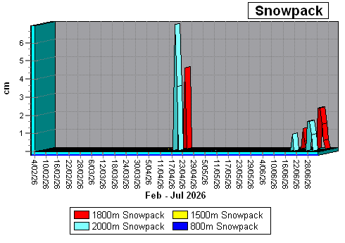
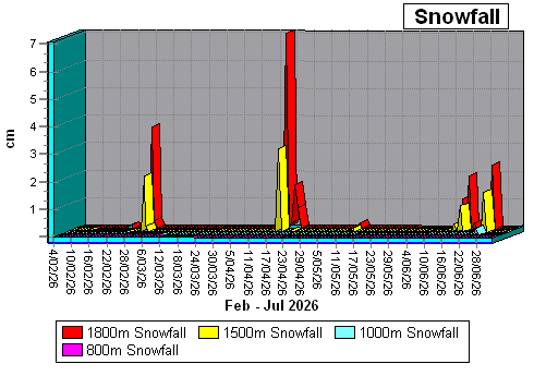
The following graphs represent calculated snowpack (and snowfall) at various altitudes in the range 800m - 2000m. It is based on extensive field data obtained of average snowpack and high altitude weather readings on Mt Rolleston's Goldney Ridge (Arthur's Pass National Park) in 2007-2009. Slope angles are based on 20º-25º (windslab is not represented in snowpack depths, but is estimated separately).
Experimental avalanche risk modelling (%) is based on calculated new snow depths, snowpack layer density, free water content, perceived crusts (rain & wind) within the overall snowpack, windslab presence, temperature, humidity and rainfall estimations. Note that the avalanche modelling functions take into account possible path travel distances of triggered avalanche events, hence low altitude areas can still show high risk although stable snow exists at these levels (visit www.avalanche.net.nz for human analysed avalanche assessments).
Notes:
- Graphs are not updated with "todays" snowfall & snow-pack data until midnight on that day when all the day's data is reassessed and crunched.
- All snowpack data for 2012 & 2013 was lost due to a lightning struck PC. The original graphs will be maintained, but no raw data is recoverable.
- Click Here to view a HTML table showing snowfall data for 2026. Click Here to save a CSV file containing snowfall data for 2026.
Snowpack Model 800m - 1800m (Last 150 days)
Snowfall Model 800m - 1800m (Last 150 days)
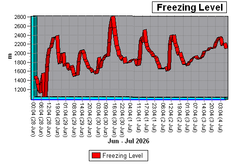
Freezing Level (Last 7 days)
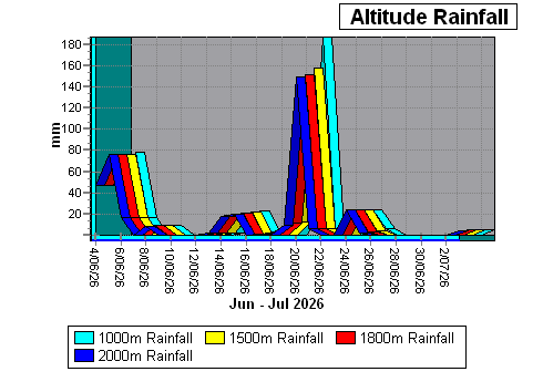
Altitude Rainfall 1000m - 2000m (Last 30 days)
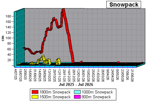
Snowpack Model 800m - 1800m (Previous 12 months)
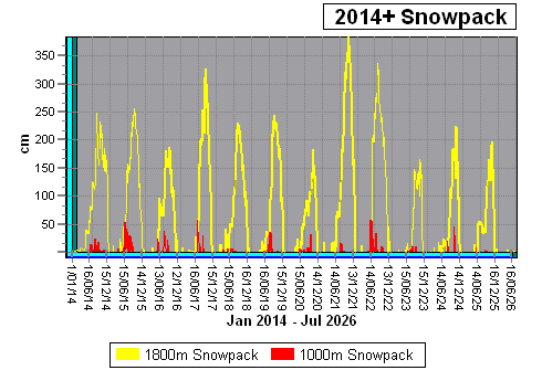
Snowpack Model 1800m (2014+)
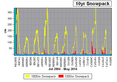
Snowpack Model 1800m (2004 - 2013)
2026 Snow Data
snowtable.csv (CSV File of 2026 data)2025 Snow Data
snowpack2025.xlsx (XLS File of 2025 data)
2024 Snow Data
snowpack2024.xlsx (XLS File of 2024 data)
2023 Snow Data
snowpack2023.xlsx (XLS File of 2023 data)
2022 Snow Data
snowpack2022.xlsx (XLS File of 2022 data)
2021 Snow Data
snowpack2021.xlsx (XLS File of 2021 data)
2020 Snow Data
snowpack2020.xlsx (XLS File of 2020 data)
2019 Snow Data
snowpack2019.xlsx (XLS File of 2019 data)
2018 Snow Data
snowpack2018.xls (XLS File of 2018 data)
2017 Snow Data
snowpack2017.xls (XLS File of 2017 data)
2016 Snow Data
snowpack2016.xls (XLS File of 2016 data)
2015 Snow Data
snowpack2015.xls (XLS File of 2015 data)
2014 Snow Data
snowpack2014.xls (XLS File of 2014 data)
2013 Snow Data
Sorry - No data available for 2013!
2012 Snow Data
snowpack2012.xls (XLS File of 2012 data)
2011 Snow Data
snowpack2011.xls (XLS File of 2011 data)
2010 Snow Data
snowpack2010.xls (XLS File of 2010 data)
2009 Snow Data
snowpack2009.xls (XLS File of 2009 data)
2008 Snow Data
snowpack2008.xls (XLS File of 2008 data)
2007 Snow Data
snowpack2007.xls (XLS File of 2007 data)
2006 Snow Data
snowpack2006.xls (XLS File of 2006 data)
2005 Snow Data
snowpack2005.xls (XLS File of 2005 data)
2004 Snow Data
snowpack2004.xls (XLS File of 2004 data)
2003 Snow Data
snowpack2003.xls (XLS File of 2003 data)
2002 Snow Data
snowpack2002.xls (XLS File of 2002 data)
SNOW MODEL
4/07/2026 05:04
Mt Rolleston (Goldney Ridge) 800m
Alt. Temp: 6.1ºC
Freezing Level: 2236m
Lapse Rate: -0.424ºC/+100m
Alt. Humidity: 88%
Alt. Min Humidity: 88%
Alt. Max Humidity: 96%
Alt. Windspeed: 12.1kmph
Alt. Av. Windspeed: 9.4kmph
Alt. Min. Windspeed: 5.4kmph
Alt. Max. Windspeed: 12.1kmph
Alt. Wind Chill: 3.6ºC
Alt. Air Pressure: 919hPa
Alt. Day Rainfall: 7.4mm
Alt. 3 Day Rainfall: 12.8mm
Last Snowfall: 248 days ago
7 Day Snowfall: 0.0cm
Snowpack Depth: 0.0cm
Mt Rolleston (Goldney Ridge) 1000m
Alt. Temp: 5.2ºC
Freezing Level: 2236m
Lapse Rate: -0.424ºC/+100m
Alt. Humidity: 87%
Alt. Min Humidity: 87%
Alt. Max Humidity: 95%
Alt. Windspeed: 14.8kmph
Alt. Av. Windspeed: 11.5kmph
Alt. Min. Windspeed: 6.6kmph
Alt. Max. Windspeed: 14.8kmph
Alt. Wind Chill: 2.1ºC
Alt. Air Pressure: 897hPa
Alt. Day Rainfall: 7.4mm
Alt. 3 Day Rainfall: 12.8mm
Last Snowfall: 9 days ago
7 Day Snowfall: 0.0cm
Snowpack Depth: 0.0cm
Mt Rolleston (Goldney Ridge) 1500m
Alt. Temp: 3.1ºC
Freezing Level: 2236m
Lapse Rate: -0.424ºC/+100m
Alt. Humidity: 85%
Alt. Min Humidity: 85%
Alt. Max Humidity: 93%
Alt. Windspeed: 52.7kmph
Alt. Av. Windspeed: 65.5kmph
Alt. Min. Windspeed: 52.7kmph
Alt. Max. Windspeed: 97.7kmph
Alt. Wind Chill: -4.0ºC
Alt. Air Pressure: 842hPa
Alt. Day Rainfall: 7.4mm
Alt. 3 Day Rainfall: 12.6mm
Last Snowfall: 9 days ago
7 Day Snowfall: 0.0cm
Snowpack Depth: 0.0cm
Windslab E: 1.1cm
Mt Rolleston (Goldney Ridge) 1800m
Alt. Temp: 1.9ºC
Freezing Level: 2236m
Lapse Rate: -0.424ºC/+100m
Alt. Humidity: 84%
Alt. Min Humidity: 84%
Alt. Max Humidity: 92%
Alt. Windspeed: 57.8kmph
Alt. Av. Windspeed: 71.8kmph
Alt. Min. Windspeed: 57.8kmph
Alt. Max. Windspeed: 107.2kmph
Alt. Wind Chill: -6.1ºC
Alt. Air Pressure: 811hPa
Alt. Day Rainfall: 7.4mm
Alt. 3 Day Rainfall: 12.4mm
Last Snowfall: 1 day ago
7 Day Snowfall: 0.0cm
Snowpack Depth: 0.0cm
Mt Rolleston (Goldney Ridge) 2000m
Alt. Temp: 1.0ºC
Freezing Level: 2236m
Lapse Rate: -0.424ºC/+100m
Alt. Humidity: 84%
Alt. Min Humidity: 84%
Alt. Max Humidity: 91%
Alt. Windspeed: 60.2kmph
Alt. Av. Windspeed: 74.8kmph
Alt. Min. Windspeed: 60.2kmph
Alt. Max. Windspeed: 111.6kmph
Alt. Wind Chill: -7.4ºC
Alt. Air Pressure: 790hPa
Alt. Day Rainfall: 7.2mm
Alt. 3 Day Rainfall: 11.8mm
Storm Snowfall (16hrs): 0.1cm
7 Day Snowfall: 0.2cm
Snowpack Depth: 0.0cm