Short Walks
 Click Here
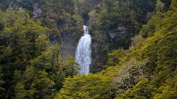
Devils Punchbowl Waterfall
Track Grade: Walking TrackWalking Time: 1 Hour Return
Features: Beech Forest, Waterfall, Native Birds
Note: In heavy rain the first creek after leaving the car-park can flood, it is unbridged. Only cross this creek if it is safe to do so!
Location: Turn onto Punchbowl Road, at West Coast end of Village, 500m from the Visitor Centre. At the end of this short gravel road is a car-park, and a signpost here points the way.
This spectacular waterfall (131m) can be seen from the main road but a walk to the base of the waterfall is well worth doing in any weather.
The track crosses the Bealey River and Punchbowl creek with the aid of two footbridges before zigzagging up steps (240 of them) through mountain beech forest to a viewing area just below the falls.
Return the same way.

The track crosses the Bealey River and Punchbowl creek with the aid of two footbridges before zigzagging up steps (240 of them) through mountain beech forest to a viewing area just below the falls.
Return the same way.


Bridal Veil Walk (a.k.a "The Arthur's Pass Walking Track")
Track Grade: Walking TrackWalking Time: 40 Minutes Return
Features: Mountain Beech, Bridal Veil Falls, viewing lookouts down the valley.
Note: In heavy rain the first creek after leaving the car-park can flood, it is unbridged. Only cross this creek if it is safe to do so!
Location: Turn onto Punchbowl Road, at West Coast end of Village, 500m from the Visitor Centre. This short gravel road ends in a car-park. A signpost here points the way (Arthur's Pass Walking Track).
This easy valley walk starts from the same carpark as the Devil's Punchbowl Waterfall walk. After the first footbridge over the Bealey River, the track goes left through old-growth mountain beech forest (Arthur's Pass Walking track). This walk takes you a lookout with a view of the Bridal Veil Waterfall and looking back to the Village, 20 minutes from the track start. The track gradient is gentle to the lookout. Return the same way.
The Arthur's Pass Walking track continues on from this point, it would take an extra 40-60 minutes (one-way) to reach the 920 metre Arthur's Pass.
The Arthur's Pass Walking track continues on from this point, it would take an extra 40-60 minutes (one-way) to reach the 920 metre Arthur's Pass.

Arthur's Pass Walking Track
Track Grade: Easy Walking TrackWalking Time: 3.5 hours return
Features: Forest walk, alpine views, bird life, waterfalls, old-growth forest.
Note: In heavy rain the first creek after leaving the car-park can flood, it is unbridged. Only cross this creek if it is safe to do so!
Location: Turn onto Punchbowl Road, at West Coast end of Village, 500m from the Visitor Centre. This short gravel road ends in a car-park. A signpost here points the way (Arthur's Pass Walking Track).
This is an attractive walk through Beech Forest and some alpine scrub to the summit of Arthur's Pass (920m). The track starts from the same carpark as the Devils Punchbowl Waterfall walk. After the first footbridge over the Bealey River, the track goes left through old-growth mountain beech forest (Bridal Veil Falls). The first part of this walk takes you a lookout with a view of the Bridal Veil Waterfall and back to the Village, 20 minutes from the track start. The track gradient is gentle to the lookout. From here you descend a staircase into the Bridal Veil canyon, then rise again onto a undulating track that takes you through stunted beech forest and some alpine meadows. After a further 20 minutes of walking you arrive at the Jacks Hut on Highway 73.
Cross the highway into the upper Bealey Valley track. The Arthur's Pass Walking Track branches to the right off the Bealey Valley track about 200 metres from the carpark. From here it slowly climbs through old-growth Beech Forest, popular with native bird species (Robins, Tomtits, Fantails, Rifleman, Bellbirds etc).The track passes into alpine wetland at a bridge across Twin Falls Stream with beautiful views of Mt Rolleston's "Rome Ridge", and towards the mountains surrounding Temple Basin skifield.
The track joins the Dobson Nature Walk at its southern entry. You could continue left into the Dobson for an easy walk of 20 minutes to the summit of Arthur's Pass (920m). Return the same way.
Return the same way.


Dobson Nature Walk
Track Grade: Walking TrackWalking Time: 30 minutes return - Nature Walk Loop. 1½ hours return - Otira Valley Extension
Features: Alpine vegetation, Views, Alpine Tarn (Lake).
Location: Top of the Pass, 5 km west of the VISITOR CENTRE. Track starts opposite the Dobson Memorial.
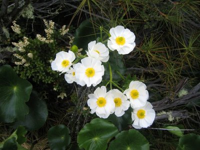
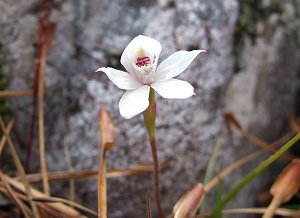
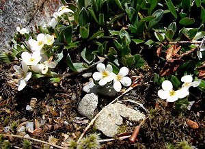
This track offers a good introduction to the sub-alpine and alpine plants of this area. The flowers are in bloom from November to February.
The evenly graded track passes through a variety of alpine herbs, tussocks and shrubs, and also has good views of the surrounding mountains.
When Lake Misery is low, you can continue on from the Nature Walk past the bog area and through tall red tussock to the Otira Valley Track.

The evenly graded track passes through a variety of alpine herbs, tussocks and shrubs, and also has good views of the surrounding mountains.
When Lake Misery is low, you can continue on from the Nature Walk past the bog area and through tall red tussock to the Otira Valley Track.


Arthur's Pass Historic Village Walk
Track Grade: PathsWalking Time: 1½ Hours Return
Features: Historic sites about Arthur's Pass Village
Route Guide: Arthur's Pass Historic Walk Brochure (PDF 428KB)
Location: Takes you around the Arthur's Pass Village. Start at the Visitor Centre.
This leisurely, easy walk takes you around the village to historic sites. At each site, photographs show you how the village used to look in the early 1900's.


Bealey Valley Track
Track Grade: Easy Tramping TrackWalking Time: 1½ hours return
Features: Sub-Alpine Forest walk, Mountain Views, Forest Birds, Bealey Chasm
Location: The start of the track is from a carpark, 3km North of Arthur's Pass Village.
This is an attractive well-graded walk through mountain beech forest to the base of Mount Rolleston. This area is old-growth beech forest and is great for forest bird-life and the diversity of vegetation types. The track starts from a car-park 3 km north of Arthur's Pass Village on SH 73. The little green Jack's Hut, an historic road worker's hut, is just across the road.
About 200m in turn left down a flight of stairs onto the Bealey Valley Track. The track is bridged across the Bealey River at "The Chasm". The Track Grade deteriorates a bit here as it rises to a tussock clearing (alpine bog) and into the sub-alpine forest again before reaching the river again after about 20-30 minutes adjacent the avalanche warning sign. This is the "official" end of the track. Return the same way.
EXTRA EXPLORING: From the avalanche sign a unmarked track continues up valley (30-40 minutes one-way). This is the mountaineers access track and can be followed into the upper valley area. In Winter / Spring this entire area can be threatened by avalanches; at any time of year it can be an active rockfall area! You will need to scramble up steep banks, and cross flowing creeks. Be very careful of loose and slippery rocks in the upper valley. Stop before you get to the "black canyon" in the head of the valley.
Warning: Avalanche debris collected at the head of the upper valley may be unstable. Large rocks and chunks of ice can fall at any time. Do not walk on the avalanche debris.


Old Coach Road
Track Grade: PathWalking Time: 30 minutes return
Features: Historical route of Cobb and Co Coach.
Location: Starts at Greyneys shelter, 6km South of Arthur's Pass Village.
This is a pleasant forest walk. It follows a gently graded section of the century-old coach road and leads back to the shelter on a more recent track. You can still see sections of old rockwalling along one part of the track.
At the Northern end of the track is a rope handrail. You can use if for guidance, so shut your eyes, and use your other senses as you move through the forest.
At the Northern end of the track is a rope handrail. You can use if for guidance, so shut your eyes, and use your other senses as you move through the forest.

Otira Valley Walk
Track Grade: Tramping Track & RouteSHORT Walking Time: 40 minutes one way to the foot-bridge.
LONG Walking Time: 2 - 3 hours one way to the head of the valley using the mountaineers route.
Features: Valley walk, Sub-alpine vegetation.
Location: The track starts at a carpark on the West side of the Summit of Arthur's Pass, approximately 7 km from Arthur's Pass Village towards the West Coast. The car-park is difficult to see when travelling from Arthur's Pass, slow down when you see the muddy Lake Misery on your left.
The track climbs over an old moraine, then follows the contour through subalpine scrub and tussock to the Otira River foot-bridge.
Beyond the bridge a unmarked route continues climbing across rock screes and boulders to the head of the valley, be careful as there is much loose rock. In Winter / Early Summer beware of avalanches onto the route above the foot-bridge.
Beyond the bridge a unmarked route continues climbing across rock screes and boulders to the head of the valley, be careful as there is much loose rock. In Winter / Early Summer beware of avalanches onto the route above the foot-bridge.


Millennium Walk / Avalanche Creek Falls
Track Grade: PathWalking Time: 10-15 Minutes Return
Features: Waterfalls, Native Bush, Viewing Platform, Night Lighting
Location: Behind Chapel in Arthur's Pass Village or start opoosite the Visitor Centre and follow pathway north along the back of the "Heli-Pad" (green field) towards Glasgow Bridge & Chapel.
This is the easiest of all the walks in Arthur's Pass Village. A short stroll up an easy inclined track takes you to a viewing platform amongst native sub-alpine forest. Waterfalls abound both below and beyond the platform. Night lighting (sunset to 11pm) provides a spectacular vista as it lights the main 50 metre high waterfall and lush vegetation. This waterfall occassionally freezes solid in winter.
Feel free to drop into the Arthur's Pass Chapel and view the waterfall through it's back window.

Feel free to drop into the Arthur's Pass Chapel and view the waterfall through it's back window.


Arthur's Pass Alpine Garden
Track Grade: Walking TrackWalking Time: 30 Minutes Return
Features: Alpine garden with named plant species
Route Guide: Arthur's Pass Alpine Garden (PDF 124KB)
Location: Highway 73, between Rough Creek Rd & School Terrace. 300m towards Christchurch from Visitor Centre.
Map:
 Click Here to open map image.
This alpine garden was established in the 1980's and has since seen further plantings of alpine plant species endemic to Arthur's Pass National Park and the Castle Hill Basin. Approximately 54 species have been identified, many have name plaques associated with them. The Alpine Garden is maintained by the Arthur's Pass Wildlife Trust (www.apwt.org.nz).
Please help us keep the garden weed free!
In recent times Russell Lupin (Lupinus polyphyllus) and Birdsfoot Trefoil (Lotus corniculatus) have started to invade our Alpine Garden. Please feel free to give these invasive weeds a hard time but pulling them out by the roots, or stripping their flower-heads.

Birdsfoot Trefoil
Russell Lupin
Please help us keep the garden weed free!
In recent times Russell Lupin (Lupinus polyphyllus) and Birdsfoot Trefoil (Lotus corniculatus) have started to invade our Alpine Garden. Please feel free to give these invasive weeds a hard time but pulling them out by the roots, or stripping their flower-heads.
Birdsfoot Trefoil
Russell Lupin
Cockayne Nature Walk
Track Grade: Walking TrackWalking Time: 30 minutes return
Features: Flora identification panels, Rain forest.
Location: Starts from the carpark at the end of the side road behind Kellys creek shelter, 20km towards the WEST COAST from Arthur's Pass Village.
This loop walk winds through the diverse Podocarp- Broadleaf forest of the West Coast. It climbs up over a small hill and comes out near the shelter.
A short connecting track leads back to the carpark.
The track is named after Dr Leonard Cockayne, a renowned botanist, who provided the original inspiration to create Arthur's Pass National Park.
A short connecting track leads back to the carpark.
The track is named after Dr Leonard Cockayne, a renowned botanist, who provided the original inspiration to create Arthur's Pass National Park.
