Mt Cassidy Route
WARNING: Because of continuing problems (including fatalities) encountered on this route by walkers please take note of the following advise...
- This is a long "day walk", leave early to allow for sufficient daylight hours.
- If there is a poor weather forecast do not attempt this route. If there is fog/cloud cover on the mountain turn around.
- TELL SOMEONE YOUR PLANS, and remember to let them know when you return safely.
- Do not walk alone on this route, find an appropriate partner.
- Take sufficient clothing, food, water & medical needs to be able to survive a night out in cold wet conditions. Search & Rescue activity should commence the day following your intended "out date".
- Test your cellphone in Arthur's Pass Village, if it works there, take it with you, it should work on all Village side aspects of this mountain, if you get lost or in trouble call 111. Don't waste your phone battery! Phones can be an unreliable way of getting help. Better still take a PLB with you as well (Arthur's Pass Visitor Centre hires them).
- If you become lost, retrace your steps if possible to refind the correct route. If you cannot, find shelter (rocks, trees, tussocks), stay where you are.
- DO NOT push into the treeline too far except to seek shelter, there are large hidden cliffs, canyons and alternate ways down DO NOT exist. If you are not on the marked track (orange triangles) STOP!
- DO NOT follow streams/creeks off the mountain, many of these go over very large waterfalls or contain extensive loose rock.
- If you see searchers (helicopter, ground crews) attract attention by moving to open ground, yelling, waving bright clothing. If you are injured leave something bright in clear view near you in case you lose consciousness.
- At night you can signal towards the Village (street lights are visible) by triggering your camera flash on every hour.
HAVE A "PLAN B": If Mt Cassidy is out of condition with poor visibility/rain/wind, consider the Bealey Spur Track as an alternative. The weather can be much finer east of Arthur's Pass.
Area Brochure: Discover Arthur's Pass Booklet (19MB)
Area Brochure: Discover Arthur's Pass Booklet (19MB)
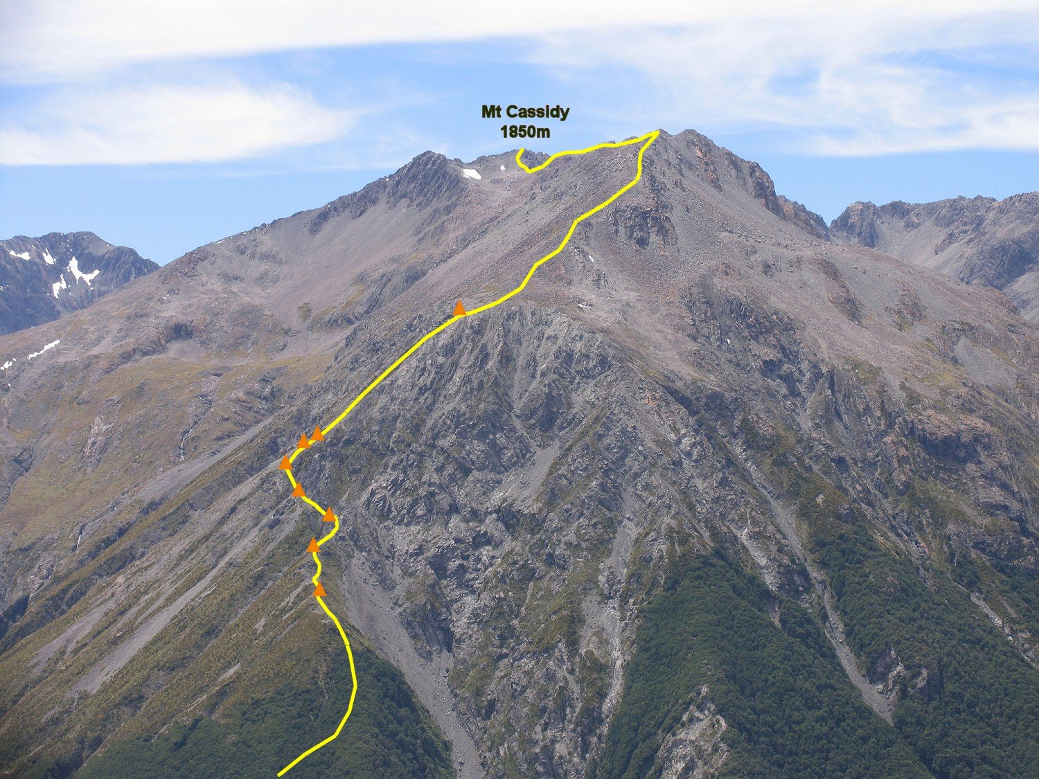
Mt Cassidy Route
Track Grade: Tramping Track & Unmarked RouteWalking Time: 6 to 8 hours return
Features: Very Steep! Rocky ridge walking, views of the village.
Location: Starts at the Punchbowl Road carpark.
Download this description as a PDF file (367Kb) - Click Here
This climbing route is not recommended as your first walk in the mountains of Arthur's Pass.
PLEASE TALK TO D.O.C. Staff before you head up this way, and DO TELL SOMEONE YOUR PLAN!
The track leaves from the Devil's Punchbowl Waterfall carpark. Head towards the Devil's Punchbowl, only cross the first bridge. The Mt Cassidy track (Con's) is hidden on a small rise on the left, about 30 metres before the second bridge.
The track is marked to treeline. It rises very steeply, very fast. The initial track sections can be quite wet and slippery. It shortly joins a ridge on the north side of Punchbowl Creek. Beware of the occasional steep drop-off towards the Punchbowl, a slip here does not forgive! The track affords good views on Mt Rolleston's Rome Ridge as irt climbs. About 200 metres before treeline, the track stops ascending, turns a sharp right, descends a few metres, then climbs very steeply to treeline.
At treeline have a very good look around you, remembering the entry point to the forest, as it is the only way down should you need to turn around, or you decide to descend this way.
Continue ascending the ridge on a vague trail, shortly a sign, and marker poles are met. Continue up the steep crumbling ridge, near the base of the large cliff looming in front of you, it moves to the north side and skirts across a loose, narrow scree gully - look for the marker poles ahead - DO NOT CLIMB THE CLIFF!
The route then sidles upwards under the base of the cliff, crossing further loose scree gullies. The route flatens out for a short distance under a spur. There won't be any further markers sidling ahead. Look back behind you, there should be a large marker triangle bolted to the rocks (remember this point). Look up the spur, there WILL BE two marker poles above you - these are the last poles on the route, and indicate the direction of travel.
Climb up the ever-loosening spur, trying to stay on it's right side, beside the steep gully - avoid climbing the gully as it contains mostly loose rock. Nearing the gully top, a cliff is met on the left, and the gully becomes very narrow (2 metres); step across the gully onto the rocks on it's right side, climbing carefully to the bouldery lesser slope above. STOP! Look below you to the right, there should be a large marker triangle bolted to the rocks (remember this point, as it's the only way off this side of the mountain).
A large boulder field is above you, continue climbing through this, it contains many very large rocks that are loose and move when trodden on - ascend carefully, aiming for the obvious ridge crest above you. The flatter, main ridge-top is joined around the 1700m contour.
This is a long ridgeline, about 1.2km to Mt Cassidy summit. Follow the main crest of the ridge, but look ahead, there is occasional opportunity to avoid climbing over all the hill tops ahead of you by sidling on the left side through loose boulder fields - not every hill is avoidable this way, and as you near Mt Cassidy you are generally forced to be on the narrowing ridgeline. THERE ARE EXTREMELY BIG CLIFFS (300m) DROPPING OFF ON YOUR RIGHT TOWARDS THE UPPER PUNCHBOWL CREEK, ALWAYS MAKE SURE ANY POTENTIAL FALL-LINE YOU HAVE IS NOT THIS DIRECTION.
About 300m before Mt Cassidy the ridge drops down into a flat saddle, with a steep scree/snow-slope in front of you, where Mt Cassidy's west ridge joins. Climb this slope to the left, making sure your fall-line goes to somewhere good (not Punchbowl Creek). If there is snow on this face, check its viability for climbing, if it is not great sidle out left in big zig zags to meet the west ridge.
It is only a short distance to Mt Cassidy (1850m). The summit has a small cairn of rocks and can be easily mistaken for just a bit of ridge. In wintry conditions, Mt Cassidy summit to notorious for having a 10m cornice of ice overhanging the Punchbowl Creek - if there's any doubt stay away.
DECISION TIME
Most people don't want to descend Con's track again, as it is steep, complex and slippery. The alternate is to descend into Temple Basin ski-field, and to the highway from there. If you do decide to reverse the route be very spacially aware, and trust you remembered the several navigational waypoints. Descend the Con's track in the forest slowly, there are a couple of places where the track turns sharply, and there are very unforgiving drop-offs ahead.
Descent to Temple Basin: From Mt Cassidy summit you have two choices...
- Via Blimit Ridge: Continue along the ridge towards Blimit (1921m). It has some narrow ridge, with drop-off towards the Punchbowl, some care is required. As you move along the ridge you'll go through two saddles, there's an opportunity at the second saddle to drop off towards Bill's Basin (where the small tarns are). Sidle carefully down the screes, moving towards the basin - avoid putting any steep drop-offs below you. Another option is to continue along onto the south ridge of Blimit, this can be quite exposed, at a point almost directly above the largest tarn in the basin, there is a very steep gut dropping off the ridge, leading into a good scree-slope leading directly to the tarn.
Once at the large tarn, continue north to the second small tarn, and to the third tarn. From here sidle left out onto the scree slope under the rocky ridge ahead. Continue sidling slightly down and right, onto the flat saddle area at the toe of the ridge. From here you should be able to see Page Shelter below you some way to the north. Continue a short distance along the ridge until you see a steep scree descending towards the shelter, descend it slowly. Once you reach the lesser tussock slopes below head west to intersect the track to the shelter (there is no need to go to the shelter).
Follow the well-benched track back south, it ends abruptly at the bull-wheel of the Temple ski tow. Do not descend the ski tow slope, instead take the steep spur on the right, it is quite steep at the top, but soon eases into a more gentle descent, with a obvious trail heading towards the ski lodges.
Blimit: Obviously an ascent of Blimit (1921m) is a tempting side-trip. Only attempt this if you are very sure on your feet, not afraid of heights, and the ridge is not iced over, or has a cornice. The ascent is quite straightforward from the saddles. It has some very exposed places. Blimit is short for "bloody limit" for the expletives used by its first ascenders due to the loose rock encountered, everywhere - this has not changed. It is best to reverse the route to get to the tarns in Bill's Basin. To travel north can put you into areas of balancing large boulders. - Via West Ridge & Cassidy Ski Tow: From Mt Cassidy descent it's west ridge, the ski-field lodge building will always be visible below you to the north. As you descend the ridge, you will note the Cassidy ski tow running towards Mt Cassidy. Eventually you will see a tussock and scree slope descending steeply into this basin with no obvious cliff lines or obstacles, carefully descend this, aiming for the lower end of the tow (small shed). Once at the tow there is no need to walk towards the main lodge building, instead follow the small rocky spur behind the shed heading west, this joins the Temple Basin track next to a bridge.