CURRENT ALERTS
Anti-Crow hut bookable from August 1st.
DOC have advised that after 1 August 2025 Anti-Crow hut will no longer be first come - first served. It will be bookable through the DOC booking system.
Serviced huts bookable online from 2 December 2025
All serviced huts in Arthur's Pass National Park (Carrington, Casey, Edwards, Hawdon) will become bookable online from 2nd December 2025. Visit DOC website for more information.
Arthur's Pass National Park - Harman Pass
Time: 4 days one way
Difficulty: Marked track, some unmarked route sections, river crossings, alpine crossing/s
Huts: Anti-Crow Hut (8 bunks - Book online), Carrington Hut (36 bunks - Book online), Julia Hut (6 bunks), Mid-Taipo Hut (6 bunks), Dillon Hut (10 bunks), Carroll Hut (10 bunks)
Features: Braided River, alpine pass on the Main Divide, podocarp forest, hot springs, Whio
Location: The track heads are 8km (Klondyke Corner) east of Arthur's Pass village, and 41km (Taipo Valley track) or 17km (Kelly Range track) west of Arthur's Pass depending where you decide to exit.


This route passes through extensive areas of active avalanche terrain in winter/spring. The terms "true-left & right" are used in this description, they refer to side of valley always looking downstream or down hill.
Klondyke Corner to Carrington Hut (4-6 hours one way)
Visit Carrington Hut Route
Carrington Hut – Julia Hut (7 hours one way)
From Carrington hut follow the signposted and marked route towards Harman Pass. After about 700m the track moves out onto the riverflats of the White River. Continue up river on the true-right. At some very large boulders in the river consider looking for a safe crossing to the true-left - you may need to explore the river for some distance to find a viable crossing (the Clough Cableway shown on some maps no longer exists!).
Once across the river continue upstream to the first of two channels of the Taipoiti River, follow this channel upstream (there is a large orange triangle on the true-right riverbank). If there is snow up the Taipoiti, the route will be difficult. During winter and spring, avalanches can funnel into the gorge over the cliffs. In early summer large, unstable ice sheets can block the central gorge area. Be aware that receding ice can leave large, dangerous, balancing boulders in the riverbed.
Climb and scramble up through the steep gorge, crossing from side to side, where necessary. At the top of the gorge, waterfalls tumble over impassable cliffs. Continue past these waterfalls. The poled route to Harman Pass starts here, beside a small stream.
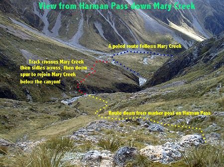
Once out of the Taipoiti gorge you can see the main Taipoiti branches into two streams, each running down a deep gully. A well-worn cairned and poled trail crosses the true left branch relatively soon, the climbs upwards, well above the true right gully. As the second stream becomes smaller, and more open, cross it. A short walk and you are at the top of Harman Pass with its large cairn of rocks. (if you are walking down from Harman Pass, enter the Taipoiti well to its true-left to avoid the bluffs and waterfalls).
Three poled routes head away from Harman Pass, one into the Taipoiti, another towards Whitehorn Pass, and your route descending into Mary Creek. From Harman Pass head downhill and slightly to the right (northwest), looking for marker poles ahead of you leading down the tussock slope.
The route continues through the bluffs below. Cross the creek and climb to the terrace by scrambling up an obvious worn trail in the low bluffs. Pole-markers indicate the way across the terrace to the open riverbed of Mary Creek. The descent to Mary Creek is relatively steep with low scrubby vegetation. Boulder-hop downstream following the pole-markers criss-crossing the creek until you reach a large orange marker on the true-left. The track to Julia Hut starts here and is well marked with orange markers. As you descend the creek it is important to be looking ahead towards the upper true-left bank where the track exits the creek.
Follow the track to the swing bridge that crosses Mary Creek a few hundred metres above its confluence with Julia Creek. Cross this bridge and follow the track for 300 metres to Julia Hut. The newer Julia Hut has an efficient stove. The older Julia Hut (4 bunks) is a few minutes further down the track.
The Julia hotspring is located about 450 m downstream on the true-right of the Taipo River, a short track leads from the hut to the river. You may need to dig them out to create a pool. In recent years the pool has been known to "erupt" spewing out very hot water. In most cases you may need to divert part of the Taipo into the pool so you can comfortably use it. Do not put your head under the water as there is a risk of contracting amoebic meningitis. Julia Hut – Mid-Taipo Hut (3-5 hours one way)
From the Julia huts follow the marked track downstream on the true-right of the Taipo River. The track crosses various side streams and alternates between riverbed and bush travel. A three wire bridge gives access across Tumbledown Creek. After 4.6km of travel the swingbridge across the blue rapids of the Taipo River is crossed. It is a further 1.5km along the bush edge, and river flats to Mid-Taipo hut.
Mid-Taipo Hut to Dillon Hut (3-5 hours one way)
Travel downstream of Mid-Taipo hut has become much slower in recent years as much of the original track on the terraces has been washed away by a flooding Taipo River. A lot of travel now is directly beside the river through bouldery terrain. Hura, Dunns and Seven Mile Creeks can all pose impassable obstacles if there is heavy rainfall - stay at Mid-Taipo hut until they subside.


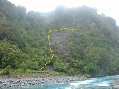
From the hut, cross Hura Creek and continue along the river flats, and a section of bush travel to the crossing of Dunns Creek. From here continue boulder-hopping beside the river or on remnant track for about 2.5km, at which point you will encounter a landslide, and the river canyons below. Looked for a taped or marked route up this slip - this slip is active and the route up it keeps changing. At the top of the slip the route sidles onto a terrace for about 700m before a descent to the Scotties three wire bridge (the Taipo River is rarely crossable, but if it is you can ford it to the true-right above the canyon, cross Hunts Creek, and continue on to join the track to Dillon hut).
Once across the Taipo River it is just over 2km to the Dillon hut.
Dillon Hut to SH73 (2-3 hours one way)
From the hut continue across the scrubby flats, passing the old Dillons Homestead. Seven Mile Creek must then be crossed, it can be difficult to cross if swift, and impossible in flood. On the other side of Seven Mile Creek you will pick up a farm track, this travels through private farmland so adhere to any signage. The track wanders along the river flats for about 5km, ocassionally moving up into the broom and gorge scrub to avoid the Taipo River where it has cut in. The road then climbs a small hill for 800m before winding its way down to the parking area on SH73.
Alternate Route: Dillon Hut to SH73 via Carroll Hut (6 hours one way)
Note: Only attempt this route in fine weather with good visibility. It should not be attempted when there is likely deep snow across the Kelly Range.
From the hut continue across the scrubby flats, passing the old Dillons Homestead. Seven Mile Creek must then be crossed. The old track up the true-left of Seven Mile Creek has been destroyed by flooding. Ascend the true-right of Seven Mile Creek for about 700m until you see the marker triangles on the true-left bank entering onto a bush track. This track passes the old gold mining water races, and shortly starts to ascend very steeply (600m vertical) up through the rata forest, joining a steep, craggy ridge with very large drop-offs into Seven Mile Creek (be careful near the edges). Once at bush-line you are half-way to Carroll hut, and still have a further 300m of vertical climb ahead of you onto the back of the Kelly Range.
Follow sparsely spaced pole-markers across the range. Be careful not to lose them, as the animal trails up here can look better than the actual track, and none go to good places! Some large alpine tarns are past, and the track passes through "rolling grounds" of boulders and alpine vegetation. A small group of shallow tarns indicates you have reached Kelly Saddle (1165m). From the saddle the marked route descends, crossing a creek, and soon arrives at the Carroll hut.

If it has been raining heavy there is a possibility that the creek at the base of the route out could be impassable; it is difficult to know, but if the streams around the hut are flowing swift and dirty, then this could be the case. It is a long haul (2-3 hours) back to the hut for protection.
From Carroll hut follow the pole-marked route across the boggy alpine meadows, where it then sidles onto the hillside adjacent a waterfall. This track crosses two avalanche paths (scree chutes) that descend from Kellys Hill above. These chutes can be active from May - November, moreso after heavy snowfalls. On occasion the track can be very icy in this area, and crampons & ice-axe may be required to cross safely.
The marked track finds tree-line at 950m ASL, then descends steeply down slippery spurs and ridges through the podocarp forest. At the base of the descent the track crosses the small side stream (mentioned above), and after 100m finds the Kellys Creek carpark. It is a short walk to SH73.
Klondyke Corner to Carrington Hut (4-6 hours one way)
Visit Carrington Hut Route
Carrington Hut – Julia Hut (7 hours one way)
From Carrington hut follow the signposted and marked route towards Harman Pass. After about 700m the track moves out onto the riverflats of the White River. Continue up river on the true-right. At some very large boulders in the river consider looking for a safe crossing to the true-left - you may need to explore the river for some distance to find a viable crossing (the Clough Cableway shown on some maps no longer exists!).
Once across the river continue upstream to the first of two channels of the Taipoiti River, follow this channel upstream (there is a large orange triangle on the true-right riverbank). If there is snow up the Taipoiti, the route will be difficult. During winter and spring, avalanches can funnel into the gorge over the cliffs. In early summer large, unstable ice sheets can block the central gorge area. Be aware that receding ice can leave large, dangerous, balancing boulders in the riverbed.
Climb and scramble up through the steep gorge, crossing from side to side, where necessary. At the top of the gorge, waterfalls tumble over impassable cliffs. Continue past these waterfalls. The poled route to Harman Pass starts here, beside a small stream.
Once out of the Taipoiti gorge you can see the main Taipoiti branches into two streams, each running down a deep gully. A well-worn cairned and poled trail crosses the true left branch relatively soon, the climbs upwards, well above the true right gully. As the second stream becomes smaller, and more open, cross it. A short walk and you are at the top of Harman Pass with its large cairn of rocks. (if you are walking down from Harman Pass, enter the Taipoiti well to its true-left to avoid the bluffs and waterfalls).
Three poled routes head away from Harman Pass, one into the Taipoiti, another towards Whitehorn Pass, and your route descending into Mary Creek. From Harman Pass head downhill and slightly to the right (northwest), looking for marker poles ahead of you leading down the tussock slope.
The route continues through the bluffs below. Cross the creek and climb to the terrace by scrambling up an obvious worn trail in the low bluffs. Pole-markers indicate the way across the terrace to the open riverbed of Mary Creek. The descent to Mary Creek is relatively steep with low scrubby vegetation. Boulder-hop downstream following the pole-markers criss-crossing the creek until you reach a large orange marker on the true-left. The track to Julia Hut starts here and is well marked with orange markers. As you descend the creek it is important to be looking ahead towards the upper true-left bank where the track exits the creek.
Follow the track to the swing bridge that crosses Mary Creek a few hundred metres above its confluence with Julia Creek. Cross this bridge and follow the track for 300 metres to Julia Hut. The newer Julia Hut has an efficient stove. The older Julia Hut (4 bunks) is a few minutes further down the track.
The Julia hotspring is located about 450 m downstream on the true-right of the Taipo River, a short track leads from the hut to the river. You may need to dig them out to create a pool. In recent years the pool has been known to "erupt" spewing out very hot water. In most cases you may need to divert part of the Taipo into the pool so you can comfortably use it. Do not put your head under the water as there is a risk of contracting amoebic meningitis. Julia Hut – Mid-Taipo Hut (3-5 hours one way)
From the Julia huts follow the marked track downstream on the true-right of the Taipo River. The track crosses various side streams and alternates between riverbed and bush travel. A three wire bridge gives access across Tumbledown Creek. After 4.6km of travel the swingbridge across the blue rapids of the Taipo River is crossed. It is a further 1.5km along the bush edge, and river flats to Mid-Taipo hut.
Mid-Taipo Hut to Dillon Hut (3-5 hours one way)
Travel downstream of Mid-Taipo hut has become much slower in recent years as much of the original track on the terraces has been washed away by a flooding Taipo River. A lot of travel now is directly beside the river through bouldery terrain. Hura, Dunns and Seven Mile Creeks can all pose impassable obstacles if there is heavy rainfall - stay at Mid-Taipo hut until they subside.

From the hut, cross Hura Creek and continue along the river flats, and a section of bush travel to the crossing of Dunns Creek. From here continue boulder-hopping beside the river or on remnant track for about 2.5km, at which point you will encounter a landslide, and the river canyons below. Looked for a taped or marked route up this slip - this slip is active and the route up it keeps changing. At the top of the slip the route sidles onto a terrace for about 700m before a descent to the Scotties three wire bridge (the Taipo River is rarely crossable, but if it is you can ford it to the true-right above the canyon, cross Hunts Creek, and continue on to join the track to Dillon hut).

Once across the Taipo River it is just over 2km to the Dillon hut.
Dillon Hut to SH73 (2-3 hours one way)
From the hut continue across the scrubby flats, passing the old Dillons Homestead. Seven Mile Creek must then be crossed, it can be difficult to cross if swift, and impossible in flood. On the other side of Seven Mile Creek you will pick up a farm track, this travels through private farmland so adhere to any signage. The track wanders along the river flats for about 5km, ocassionally moving up into the broom and gorge scrub to avoid the Taipo River where it has cut in. The road then climbs a small hill for 800m before winding its way down to the parking area on SH73.
Alternate Route: Dillon Hut to SH73 via Carroll Hut (6 hours one way)
Note: Only attempt this route in fine weather with good visibility. It should not be attempted when there is likely deep snow across the Kelly Range.
From the hut continue across the scrubby flats, passing the old Dillons Homestead. Seven Mile Creek must then be crossed. The old track up the true-left of Seven Mile Creek has been destroyed by flooding. Ascend the true-right of Seven Mile Creek for about 700m until you see the marker triangles on the true-left bank entering onto a bush track. This track passes the old gold mining water races, and shortly starts to ascend very steeply (600m vertical) up through the rata forest, joining a steep, craggy ridge with very large drop-offs into Seven Mile Creek (be careful near the edges). Once at bush-line you are half-way to Carroll hut, and still have a further 300m of vertical climb ahead of you onto the back of the Kelly Range.
Follow sparsely spaced pole-markers across the range. Be careful not to lose them, as the animal trails up here can look better than the actual track, and none go to good places! Some large alpine tarns are past, and the track passes through "rolling grounds" of boulders and alpine vegetation. A small group of shallow tarns indicates you have reached Kelly Saddle (1165m). From the saddle the marked route descends, crossing a creek, and soon arrives at the Carroll hut.

If it has been raining heavy there is a possibility that the creek at the base of the route out could be impassable; it is difficult to know, but if the streams around the hut are flowing swift and dirty, then this could be the case. It is a long haul (2-3 hours) back to the hut for protection.
From Carroll hut follow the pole-marked route across the boggy alpine meadows, where it then sidles onto the hillside adjacent a waterfall. This track crosses two avalanche paths (scree chutes) that descend from Kellys Hill above. These chutes can be active from May - November, moreso after heavy snowfalls. On occasion the track can be very icy in this area, and crampons & ice-axe may be required to cross safely.
The marked track finds tree-line at 950m ASL, then descends steeply down slippery spurs and ridges through the podocarp forest. At the base of the descent the track crosses the small side stream (mentioned above), and after 100m finds the Kellys Creek carpark. It is a short walk to SH73.